The Icelandic language is one of the more difficult ones I have encountered on my travels. Its roots stretch back to the Old West Norse dialects spoken by Viking settlers more than a thousand years ago, and many of those ancient words and complicated grammatical rules have survived into modern Icelandic.
Fortunately for foreign travelers, Icelanders speak very good English.
I mention this because traveling around Iceland can sometimes feel like an exercise in phonetic acrobatics. And on the Snæfellsnes Peninsula, some of the most incredible places you will visit also happen to have some of the most intimidating names to pronounce.
But don’t let the names stop you.
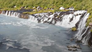
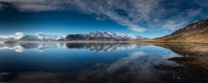
Not far from Reykjavik, the Snæfellsnes Peninsula stretches approximately 56 miles (90 km) into the Atlantic Ocean. Within this relatively small area are glaciers, lava fields, waterfalls, black beaches, basalt cliffs, fishing villages, and landscapes wrapped in centuries of Icelandic folklore.
It is often described as a miniature Iceland.
After spending a day driving around the peninsula, I think that description is accurate. But Snæfellsnes also feels like something more.
This is a place where volcanic formations become petrified trolls, mountains resemble witches’ hats, and moss-covered gorges look like they might conceal something from an Icelandic fairy tale.
Why Visit the Snæfellsnes Peninsula?
The Snæfellsnes Peninsula gives you an opportunity to experience many of Iceland’s characteristic landscapes without driving the entire 828-mile (1,332 km) Ring Road. Within a relatively compact area, you can encounter lava fields, beaches, waterfalls, mountains, basalt formations, and small coastal villages. That variety makes Snæfellsnes particularly appealing if you only have a few days in Iceland.
What Makes Snæfellsnes Special?
What struck me most about Snæfellsnes was how quickly the landscape changed. You can go from watching seals on a golden beach to standing beside a tiny black church surrounded by lava fields, then find yourself walking through a moss-covered gorge shortly afterward.
Some of the highlights include:
- Golden beaches where harbor and grey seals gather
- Ancient lava fields
- Moss-covered gorges and waterfalls
- Dramatic basalt cliffs
- Black pebble beaches
- Small Icelandic fishing villages
- Strange volcanic formations associated with local folklore
- Kirkjufell, one of Iceland’s most recognizable mountains
The distances between many of these places are relatively short, but that can be deceptive. There is so much to stop and explore that driving around Snæfellsnes can easily consume an entire day. That is precisely what happened to me.
How Long Should You Spend on the Snæfellsnes Peninsula?
Although sightseeing tours leave Reykjavik for one-day trips around Snæfellsnes, I recommend staying at least one night on the peninsula. Trying to drive from Reykjavik, complete the loop, and return to the capital in a single day means you will inevitably have to rush or skip places.
I arrived on August 13 and stayed at Miðhraun Lava Resort, a family-owned property with cottages and apartments. Located roughly a 90-minute drive from Reykjavik, it provided a convenient base for beginning my drive around the peninsula the following morning.
Can You Visit Snæfellsnes as a Day Trip From Reykjavik?
Yes, it is possible to visit Snæfellsnes on a day trip from Reykjavik. But based on my experience, I think an overnight stay gives you much more freedom to stop, hike, and explore instead of constantly watching the clock.
If you are planning your itinerary, consider:
- One day: Possible, but expect a long and busy day.
- One night: Gives you significantly more time for the major stops.
- Early start: Particularly useful if you want to hike or photograph popular locations.
- Self-driving: Gives you the flexibility to spend more time at places that interest you.
- Summer travel: Long daylight hours make fitting multiple stops into the day considerably easier.
Even after staying overnight and starting early, I still had to pass several places without spending much time there. Snæfellsnes may look small on a map, but there is a surprising amount packed into the peninsula.
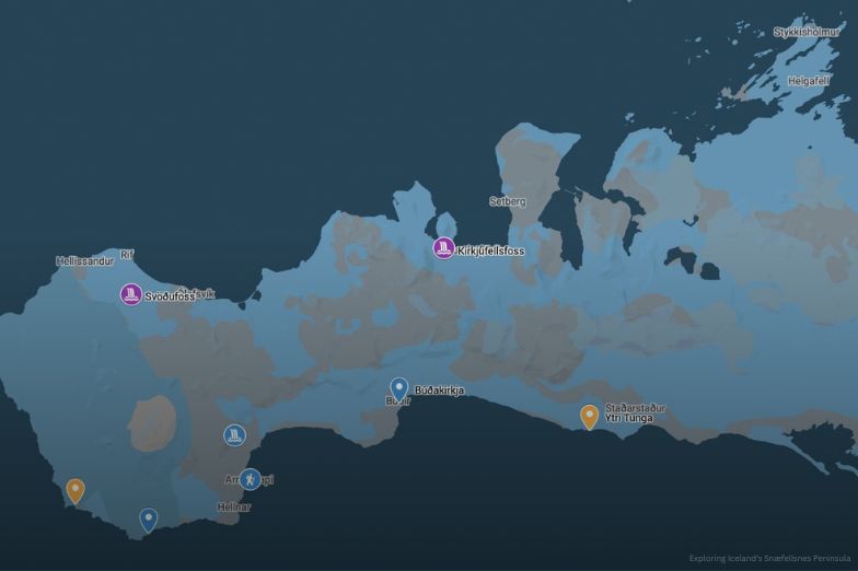
Snæfellsnes Driving Route at a Glance
| Stop | Main Highlight | What to Expect |
|---|---|---|
| Ytri Tunga | Seals and golden sand | Wildlife and coastal scenery |
| Búðakirkja | Historic black church | Lava fields and photography |
| Rauðfeldargjá | Moss-covered gorge | Short hike and water crossings |
| Arnarstapi | Basalt coastline | Coastal hiking and birdlife |
| Lóndrangar | Basalt sea towers | Volcanic geology and folklore |
| Djúpalónssandur | Black pebble beach | Lava formations and maritime history |
| Svöðufoss | Basalt-framed waterfall | Quiet hike and fewer visitors |
| Kirkjufellsfoss | Kirkjufell views | One of the peninsula's classic photographs |
With an early start, I traveled clockwise around the peninsula. And this is where both the names and the scenery started getting interesting.
Ytri Tunga Beach
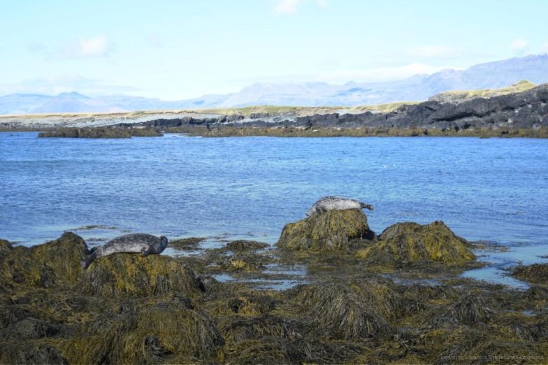
Ytri Tunga Beach was our first major stop along the southern side of the Snæfellsnes Peninsula. Unlike many Icelandic beaches famous for black volcanic sand, Ytri Tunga has golden-yellow sand and is known as one of the more reliable places in Iceland to see seals. We visited during summer and saw several seals swimming near the beach and resting on the rocks.
Seeing the Seals at Ytri Tunga
Summer is a particularly good time to look for harbor and grey seals at Ytri Tunga. They may be swimming offshore or resting on rocks, although you shouldn’t expect them to be conveniently posing a few feet away.
A few things are worth keeping in mind:
- Look along the rocks as well as in the water.
- Give the seals plenty of space.
- Bring a camera with a strong optical zoom.
- Allow some time simply to watch the shoreline.
- Don’t expect every seal to be close enough for a photograph.
I was glad I had a high optical-zoom lens because we couldn’t get particularly close to the seals. The quiet golden beach and wildlife make Ytri Tunga a gentle introduction to Snæfellsnes. Continue west, however, and the landscape begins to become considerably stranger.
Búðakirkja
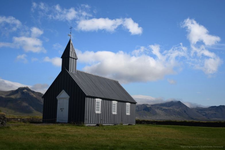
Búðakirkja is a tiny black church standing almost by itself within the Búðahraun lava field. Dating from the early 18th century, it has become one of the most photographed churches in Iceland. Its popularity makes sense once you see the setting.
Why Is Búðakirkja So Photogenic?
Búðakirkja is visually striking because there is very little around it. The black church stands against a broad landscape of lava fields and mountains, creating a scene that feels much more isolated than you might expect from such a famous location.
What makes the stop memorable is its simplicity:
- A small historic black church
- Barren lava fields
- Mountains in the distance
- Open Icelandic landscape
- More than 300 years of history
- An almost storybook-like atmosphere
Standing there, it is easy to let your imagination wander.
Perhaps a village once existed here. Perhaps something still lives among the lava rocks.
Of course, it is just a little Icelandic church.
But it doesn’t really look like it.
Rauðfeldargjá Gorge
Rauðfeldargjá, or Redfield Gorge, offers a completely different experience from the open landscapes surrounding Búðakirkja. From the roadside, we walked roughly 15 minutes along a mossy trail toward a narrow opening in the mountainside. Once you enter the gorge, the trail and the stream essentially become the same thing.
Hiking Into Rauðfeldargjá
The beginning of the walk is relatively straightforward, but exploring deeper into Rauðfeldargjá becomes more adventurous. We navigated wet rocks and ankle-deep water while the steep, moss-covered walls rose around us.
Expect:
- About a 15-minute approach from the roadside
- A stream running alongside the trail
- Wet and slippery rocks
- Ankle-deep water in places
- Cascading waterfalls farther inside
- Steep moss-covered canyon walls
- More technical scrambling if you continue deeper
- Crowds near the entrance during high season
The gorge itself isn’t enormous, but you can continue farther inside if you are comfortable climbing around the cascading water.
There is something about walking into a narrow, moss-covered gorge with water beneath your feet that makes you instinctively look around for something that shouldn’t be there. In Iceland, where stories about elves and hidden people have existed for generations, Rauðfeldargjá seems almost designed for such tales.
Arnarstapi
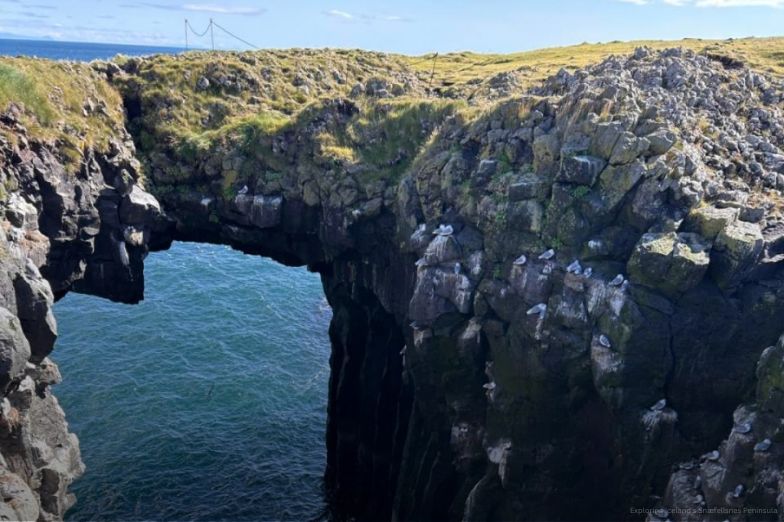
Arnarstapi is a small coastal village and a good place to stop for lunch, but the surrounding coastline is the real attraction. The approximately 4-mile Arnarstapi-Hellnar coastal trail passes dramatic basalt formations, sea cliffs, and large colonies of seabirds. One of the best-known formations along the coast is Gatklettur, or Arch Rock.
Walking the Arnarstapi Coast
The coastal path is well laid out and offers some of the most impressive ocean scenery on the peninsula. The combination of enormous basalt cliffs and Atlantic waves gives this stretch of Snæfellsnes a distinctly wild character.
Highlights include:
- The Arnarstapi-Hellnar coastal trail
- Gatklettur, or Arch Rock
- Basalt cliffs and formations
- Views across the North Atlantic
- Gulls
- Fulmars
- Kittiwakes
- Arctic terns
This is somewhere I could easily have spent considerably more time. There are also accommodations in Arnarstapi if you want to use the village as a base.
With waves crashing against the basalt cliffs and seabirds circling overhead, the landscape doesn’t need much assistance from folklore to seem mythical.
Lóndrangar
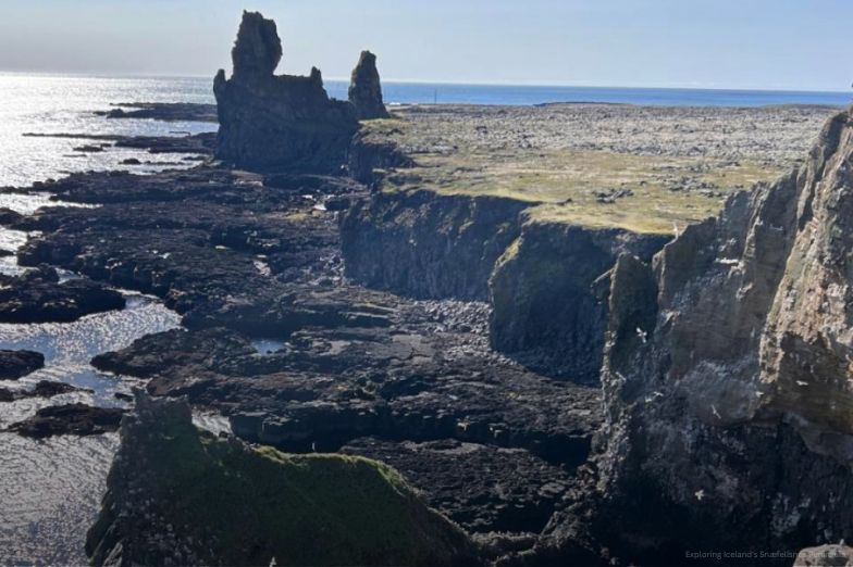
Farther along the southern coast are the enormous basalt sea towers of Lóndrangar. Rising above the North Atlantic, these formations are remnants of an ancient volcanic crater that has been gradually shaped by erosion. But geology is only half the story.
The Trolls of Lóndrangar
With the right light and a little imagination, the two formations resemble enormous rocky fortresses. Icelandic folk stories provide a more imaginative explanation, the formations were said to be trolls petrified by sunlight.
At Lóndrangar, you will find:
- Two dramatic basalt sea towers
- Svalþúfa, rising approximately 246 feet (75 meters)
- Þúfubjarg, approximately 200 feet (61 meters)
- Viewing platforms overlooking the coast
- Atlantic Ocean scenery
- Remnants of a collapsed volcanic crater
- Icelandic folklore involving petrified trolls
Geologically, wind, rain, snow, and ocean waves have spent millennia shaping these volcanic remnants.
But I think the geological explanation and Icelandic folklore can coexist quite nicely.
One tells you how the rocks were formed.
The other tells you how they feel.
Djúpalónssandur
Near the western end of Snæfellsnes is Djúpalónssandur, a crescent-shaped bay known for its Black Lava Pearl Beach. The shore is covered with remarkably smooth black pebbles surrounded by dark lava formations and the North Atlantic. It is beautiful, but there is also a darker side to this landscape.
Black Lava Pearls and the Epine GY7 Shipwreck
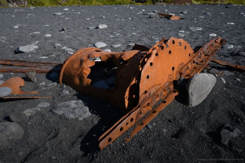
Scattered among the volcanic scenery are iron remains from the British trawler Epine GY7, which was wrecked east of the cove on March 13, 1948. The pieces that washed ashore have been left in place in memory of the fourteen English fishermen who lost their lives.
Things to notice at Djúpalónssandur include:
- Smooth black pebbles called Djúpalónsperlur, or Pearls of Djúpalón
- Dark volcanic rock formations
- The crescent-shaped bay
- Views of the North Atlantic
- Iron remains from the Epine GY7
- The dramatic contrast between the black shoreline and ocean
The beach almost looks as though truckloads of polished black stones have been scattered across it.
Walking across those smooth black pebbles while surrounded by lava formations and the North Atlantic feels slightly unreal. I can only imagine how much darker the landscape becomes during fall and winter, when harsher weather sends waves pounding against the shoreline.
Driving Across the Snæfellsnes Peninsula
By the time we reached the western end of Snæfellsnes, much of the day had already disappeared. We still had to travel back along the northern coast, which meant we couldn’t properly explore every remaining stop.
We passed places including Saxhóll Crater and Öndverðarnes Cape without spending much time at either.
Why an Overnight Stay Makes a Difference
This part of the journey reinforced why I don’t recommend trying to squeeze Snæfellsnes into a rushed day trip from Reykjavik. Even with an early start and the long daylight hours of August, there was simply too much to see.
Our experience highlighted several practical lessons:
- Distances on the map can be misleading.
- Photography stops can take longer than expected.
- Short hikes quickly add time to the itinerary.
- Some locations deserve more than a quick roadside stop.
- Long summer days help, but they don’t eliminate the need to prioritize.
- Staying overnight gives you substantially more flexibility.
Trying to see everything would have meant rushing through the places we did visit.
I’d rather miss a few stops than experience the entire peninsula through the windshield.
Svöðufoss Waterfall
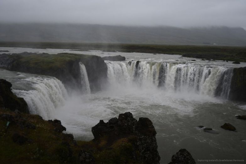
Our final two major stops were waterfalls, beginning with Svöðufoss just east of Rif. Formed by the Hólmkelsá River, the waterfall is framed by geometric basalt columns and sits away from the immediate noise of the road. The short walk to reach it is part of what makes the place appealing.
Hiking to Svöðufoss
The trail to Svöðufoss is approximately 0.5 miles from the parking area. Compared with some of the peninsula’s better-known attractions, we encountered relatively few people here.
The stop offers:
- An approximately 0.5-mile walk
- A 33-foot (10-meter) waterfall
- Geometric basalt columns
- Open Icelandic scenery
- A quieter atmosphere
- Fewer visitors than some of the peninsula’s famous landmarks
There is no enormous spectacle at Svöðufoss. Instead, it is the combination of the waterfall, basalt columns, and peaceful surroundings that makes it memorable.
It feels like one of those places that Iceland hasn’t quite finished revealing.
Kirkjufellsfoss and Kirkjufell
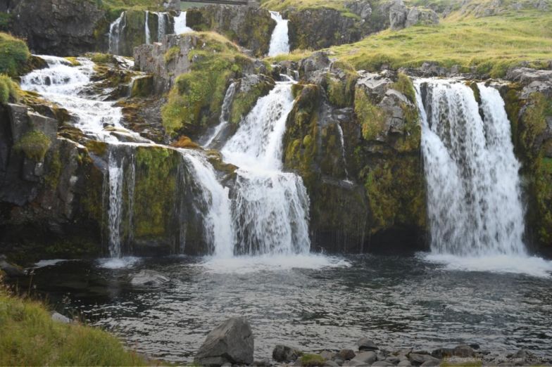
Our final stop was also the most famous and photogenic location on the entire loop. Kirkjufellsfoss sits in front of Kirkjufell, a distinctive 1,519-foot (463-meter) mountain that dominates the surrounding landscape.
The waterfall itself is relatively small. The setting is what makes it extraordinary.
Why Is Kirkjufellsfoss So Famous?
Kirkjufellsfoss is only around 16 feet (5 meters) high, but the view places the waterfall directly in front of Kirkjufell’s distinctive cone-shaped profile. The mountain has often been compared to a witch’s hat, creating one of those compositions that almost seems designed specifically for photographers.
What to expect:
- Kirkjufell rising 1,519 feet (463 meters)
- Kirkjufellsfoss at approximately 16 feet (5 meters)
- A distinctive cone-shaped mountain
- A double waterfall in the foreground
- One of the peninsula’s classic photography locations
- Significant crowds around popular viewpoints
The popularity does create a challenge. Getting a photograph without people moving up and down the trail can become a test of patience.
Still, when you finally get the view you came for, it is easy to understand the attraction.
A waterfall flowing beneath a mountain shaped like a witch’s hat sounds almost too perfect to be real.
And yet, there it is.
Snæfellsnes Peninsula Quick Guide
| Planning Question | My Experience |
|---|---|
| Can you visit from Reykjavik? | Yes, but I recommend staying overnight |
| How long is the peninsula? | Approximately 56 miles (90 km) |
| Best approach | Start early and allow plenty of time for unplanned stops |
| Driving direction | I traveled clockwise |
| Good for photography? | Extremely |
| Good for hiking? | Yes, with both short walks and longer coastal trails |
| Wildlife | Seals and numerous seabirds |
| Landscape highlights | Lava fields, beaches, basalt cliffs, waterfalls and mountains |
| Biggest planning mistake | Trying to fit too many stops into one day |
Is the Snæfellsnes Peninsula Worth Visiting?
If you only have a few days in Iceland and don’t have time to drive the entire Ring Road, I would include the Snæfellsnes Peninsula in your itinerary. More importantly, I would make it an overnight trip and get an early start for the loop.
Snæfellsnes really is a miniature Iceland, but after traveling around it, I think it feels like something more.
Where Geology and Folklore Meet
Perhaps it is the ancient Icelandic names that seem almost impossible to pronounce. Perhaps it is the black lava fields, moss-covered gorges and strange basalt formations, or perhaps it is the stories of trolls, elves and other creatures that have been woven into the landscape for generations.
Snæfellsnes brings together:
- Volcanic geology
- Icelandic folklore
- Black and golden beaches
- Waterfalls
- Wildlife
- Historic settlements
- Mountains
- Lava fields
- Some exceptionally difficult place names
Whatever the reason, there are moments on Snæfellsnes when the distinction between geology and folklore seems to blur a little.
A rock formation becomes a troll.
A mountain becomes a witch’s hat.
A moss-covered gorge becomes the perfect hiding place for something you probably don’t want to meet.
And a tiny black church sitting alone in a lava field looks as though it has been waiting there for a story to begin.
It is an enchanting part of Iceland.
Just don’t ask me to pronounce all the names.
Ready to Plan Your Next Adventure?
One of the things I love most about traveling is having enough time to explore extraordinary landscapes, discover places I wasn’t expecting, and enjoy the journey without rushing from one attraction to another. Through Hourglass Expeditions, my Luxury & Adventure Travel Agency, I can help you plan a thoughtfully designed journey built around the destinations and experiences you want to discover.
Whether Iceland is next on your list or you’re dreaming about somewhere completely different, I’d love to help turn that idea into your next adventure. And if you’d rather explore the world by sea, take a look at my Affordable Cruises and find an itinerary that might inspire your next journey. Contact our team today to learn more!
Frequently Asked Questions About the Snæfellsnes Peninsula
Is the Snæfellsnes Peninsula worth visiting?
Yes. I found the Snæfellsnes Peninsula to be one of those places where you can experience an impressive variety of Icelandic landscapes within a relatively small area. You can see waterfalls, lava fields, beaches, basalt cliffs, wildlife and small fishing villages, which is why the peninsula is often described as a miniature version of Iceland.
How many days do you need for the Snæfellsnes Peninsula?
I recommend spending at least one night on the Snæfellsnes Peninsula rather than trying to squeeze everything into a day trip from Reykjavik. Even with an early start and the long daylight hours of August, I still had to skip or shorten some stops because there was simply too much to see.
Can you visit the Snæfellsnes Peninsula on a day trip from Reykjavik?
Yes, you can visit Snæfellsnes as a day trip from Reykjavik, and there are sightseeing tours that make the journey. However, based on my experience, staying overnight gives you much more time to hike, take photographs and explore without constantly worrying about getting back to Reykjavik.
How far is the Snæfellsnes Peninsula from Reykjavik?
The Snæfellsnes Peninsula is not far from Reykjavik, making it relatively easy to include in a shorter Iceland itinerary. I stayed at Miðhraun Lava Resort, which was about a 90-minute drive from Reykjavik and provided a convenient base for exploring the peninsula.
What are the best places to visit on the Snæfellsnes Peninsula?
Some of my favorite stops were Ytri Tunga Beach, Búðakirkja, Rauðfeldargjá Gorge, Arnarstapi, Lóndrangar, Djúpalónssandur, Svöðufoss and Kirkjufellsfoss. Each offers something different, from seals and waterfalls to black beaches, basalt formations and Icelandic folklore.
Where can you see seals on the Snæfellsnes Peninsula?
Ytri Tunga Beach is one of the more reliable places in Iceland to see harbor and grey seals. I saw several during my summer visit, although they weren’t always close to shore, so I recommend bringing a camera with a good optical zoom.
Is the Snæfellsnes Peninsula good for hiking?
Yes. There are opportunities ranging from relatively short walks to longer coastal hikes. I particularly enjoyed entering Rauðfeldargjá Gorge, while the approximately 4-mile Arnarstapi-Hellnar coastal trail offers dramatic basalt formations, Atlantic views and plenty of birdlife.
What is the most famous attraction on the Snæfellsnes Peninsula?
Kirkjufell and nearby Kirkjufellsfoss are probably the most recognizable sights on the peninsula. Kirkjufell’s distinctive cone-shaped profile rises behind the small waterfall, creating one of the most photographed landscapes in Snæfellsnes.
Can you drive around the Snæfellsnes Peninsula yourself?
Yes, and driving gave me the flexibility to decide how much time I wanted to spend at each stop. I traveled clockwise around the peninsula, but I quickly discovered that short hikes, photography stops and unexpected places can make the journey take much longer than the distances on a map might suggest.
Why is Snæfellsnes called "Iceland in Miniature"?
Snæfellsnes is often described this way because so many of Iceland’s characteristic landscapes are concentrated within one peninsula. During my trip, I encountered lava fields, waterfalls, mountains, beaches, basalt cliffs, wildlife and coastal villages, all without having to drive Iceland’s entire Ring Road.